Article
Agricultural Lands in Azerbaijan: Current Usage Situation, Problems and Solutions
Akif Valiyev 1,†![]() , Abdulrahim
Dadashov 2,†,*
, Abdulrahim
Dadashov 2,†,*![]() , Gulnara Jafarova 1
, Gulnara Jafarova 1![]() , Vusala Babayeva1
, Vusala Babayeva1![]() and Khayyam Javadzada 3
and Khayyam Javadzada 3![]()
1 Agrarian Research Center, Baku AZ1106, Azerbaijan; akif.valiyev@atm.gov.az (A.V.); gulnara.cafarova@atm.gov.az (G.J.); vusala.babayeva@atm.gov.az (V.B.)
2 Center for Analysis of Economic Reforms and Communication, Baku AZ1001, Azerbaijan
3 Azerbaijan State University of Economics, Zagatala AZ6200, Azerbaijan; xayyam1984@mail.ru
* Correspondence: abdulrahim.dadashov@ereforms.gov.az
† These authors contributed equally to this work.
|
Citation: Valiyev, A.,
Dadashov, A., Jafarova, G., Babayeva, V., & Received: 21 September 2025 Revised: 21 October 2025 Accepted: 27 October 2025 Published: 28 November 2025
Copyright: © 2025 by the authors. Licensee SCC Press, Kowloon, Hong Kong S.A.R., China. This article is an open access article distributed under the terms and conditions of the Creative Commons Attribution (CC BY) license (https://creativecommons.org/licenses/by/4.0/). |

Abstract:
Efficient utilization of agricultural land is vital for sustainable food security and rural development. In Azerbaijan, however, the gap between potential and actual land productivity remains substantial due to ecological degradation, institutional fragmentation, and outdated management systems. This study applies an integrated descriptive–analytical approach to assess land-use efficiency across different ownership types and agro-ecological zones. Using official datasets from the Ministry of Economy, the State Statistical Committee, and the State Committee for Land and Cartography, a composite Land Efficiency Index (LEI) is developed, incorporating land-use coefficients, soil bonitation scores, and irrigation adequacy indicators. Results show that while 59.2% of Azerbaijan’s territory is classified as agricultural land, only 30%–65% of its productive potential is utilized. Spatial disparities are most significant in the Kura–Araz lowland and foothill plains, where salinization, erosion, and irrigation deficiencies restrict yields. The study links soil quality with governance and cadastral efficiency, offering a new framework for quantifying institutional impacts on productivity. Policy recommendations include (i) modernization of bonitation and valuation methods, (ii) digitization of cadastral data via a unified National Land Information Platform, and (iii) creation of a State Land Bank to improve land circulation and investment access. Economic feasibility analysis indicates that land rehabilitation and irrigation modernization yield an Internal Rate of Return (IRR) of 16%–18% and a payback period of 5–6 years, confirming their viability for enhancing Azerbaijan’s ecological resilience and rural economic sustainability.Keywords:
agricultural lands; land use conditions; land fund; potential productivity of land; existing problems; efficient use of land1. Introduction
Land is one of the main natural resources available to ensure human survival. Therefore, throughout history, land use and protection, preservation of fertility, and enhancement have always been at the center of attention for people who understand its value.
Although land is the primary guarantee of human existence, as society develops, anthropogenic impacts on land have intensified, leading to a decrease in productive lands. According to estimates by the United Nations (UN), due to the increasing population and inefficient agricultural practices, approximately 12 million hectares of arable land are lost globally each year. If this trend continues, by the end of the 21st century, 1 billion hectares of productive land will become unusable. On the other side, global climate change, as one of the main factors affecting agricultural production, contributes to the reduction of water resources, as well as the acceleration of desertification and the expansion of salinization processes. As a result, the level of land supply per capita continues to decline.
Taking into account the pace of population growth, global food production must increase by 25–30 million tons annually. For every newborn, approximately 0.3 hectares of land is required to produce sufficient food (Rozov et al., 1984). According to rough estimates, 15% of the world population, around 250 million, are children, and nearly 1 billion people in total suffer from hunger. Due to concerns about food security, many countries, especially developed ones, purchase or lease agricultural land in other countries. In general, over the past few years, about 200 million hectares of land worldwide have been leased or sold. All these points provide a strong basis for the argument that the maximum efficient use and preservation of land resources must be ensured unequivocally.
Recent research has further emphasized the interplay between land governance, digital agriculture, and sustainability transitions (Food and Agriculture Organization of the United Nations [FAO], 2021; Valiyev & Mirzayev, 2023). These studies highlight that integrating institutional reforms with precision farming technologies can substantially enhance land productivity and resilience.
Whether in countries around the world or in Azerbaijan, the role of land use in ensuring the sustainable development of the agricultural sector holds significant importance. Therefore, considering that agricultural production is regarded as the main purpose of use within the overall land fund of our country, studying the current status and quality of agricultural land use, identifying existing problems in land usage, and proposing solutions for their elimination are among the key directions for ensuring the sustainable development of the agricultural sector.
2. Materials and Methods
The research employed a descriptive-analytical design to evaluate the current status, constraints, and development potential of agricultural land use in Azerbaijan. Official data from the Ministry of Economy, the State Statistical Committee, and the State Committee for Land and Cartography were utilized to describe the structure of the national land fund and the extent of lands suitable for agricultural production. Information on irrigation, reclamation, and hydrogeological conditions was obtained from reports of the Azerbaijan State Water Resources Agency (ASWRA).
Quantitative assessment involved calculating the land use coefficient (Ta = Sf : Sb), defined as the ratio of the actual area in use to the total available area. Soil bonitation scores and crop-specific productivity benchmarks were applied to determine the potential productivity capacity of agricultural soils (Tmq) and the proportion of this potential realized in practice (Tih). These indicators provided a basis for comparing theoretical yield potential with actual outputs. Soil bonitation is a scientifically grounded system for evaluating the productive qualities of soils, expressed in scores depending on the fertility level. An increase of 10 bonitation points on average leads to a rise in cereal yields by 3–4 centners per hectare (Gavrilyuk, 1974).
The analysis also addressed the classification of agricultural land by ownership (state, municipal, private) using legislative and cadastral records. Methodological attention was given to issues of land valuation, agro-industrial classification, soil salinization, erosion, and the adequacy of technical and material support to farms.
As the study relied exclusively on secondary statistical and documentary sources, no experiments on humans or animals were conducted, and ethical approval was not required. No new datasets or computer code were generated. Generative artificial intelligence (GenAI) tools were used only to refine the clarity and coherence of language; they did not influence methodological choices or analytical outcomes.
In addition to conventional descriptive statistics, a composite Land Efficiency Index (LEI) was developed, integrating land-use coefficient, soil bonitation score, and irrigation adequacy ratio to better quantify the productivity gap.
2.1. Analytical and Statistical Framework
To ensure analytical depth beyond descriptive evaluation, the study framework allows for integration of advanced statistical techniques such as Structural Equation Modeling (SEM) to analyze causal relationships between land productivity and institutional variables, and Cluster Analysis to classify agro-ecological zones by efficiency levels. Future research can further employ Bayesian estimation to evaluate uncertainty in productivity forecasts.
2.2. Data Sources and Validation
The data utilized in this study were derived from official national sources, including the Ministry of Economy, the State Statistical Committee, and the Azerbaijan State Water Resources Agency. To ensure transparency and methodological consistency, all figures were cross-checked with external databases such as the Land Degradation Assessment report.
The apparent discrepancy between 351.4 thousand hectares and 348.8 thousand hectares of irrigated land affected by salinization arises from the use of different classification years and measurement methodologies across institutions. After harmonization, the validated estimate for the 2024 baseline year is approximately 350 thousand hectares. This unified figure reflects the most recent and reliable assessment available for Azerbaijan’s irrigated agricultural lands.
3. Results
3.1. Current Land Use Status of Agricultural Lands
The relief of Azerbaijan is complex, and according to its formation, it is divided into two parts: mountainous and lowland. The mountainous part constitutes 60% of the total area of the republic. The lowland area makes up 40% of the total territory and 18% of it lies up to 28 meters below sea level.
Similar to its relief, Azerbaijan is characterized by diverse climate and vegetation. In the plains and foothill regions—intensively used for agriculture—annual precipitation is very low (200–300 mm), decreasing further to 150 mm eastward. Most precipitation falls in spring and autumn, with only 10%–15% occurring in summer, and the humidity coefficient is below 0.5 (Eyyubov, 1975; Shikhlinsky, 1969). These regions also have 2,000–2,700 sunny hours annually, accumulating significant heat that favors the development of various agricultural sectors, though summers are hot. All these factors necessitate irrigated farming: about 98% of irrigated lands are located here, and 85%–90% of agricultural products are produced on these lands. According to Kovalev (1966), the regional climate and vegetation also influence soil formation, resulting in diverse soil types such as yellow soils, brown soils, chestnut soils, and steppe.
The complex relief and climatic features of the Republic have led to the formation of a rich vegetation cover. Over 4,100 plant species can be found in Azerbaijan, of which 9% are endemic, meaning they are found exclusively in Azerbaijan (Gadzhiev, 1970; Prilipko, 1970).
A number of scientists, as a result of their research, have determined that Azerbaijan’s natural geographical conditions are so rich and complex, along with the influence of ancient agricultural traditions, that they have led to the formation of various types and varieties of soils. At the same time, in some cases, the soils reflect azonal characteristics, that is, they display the principle of vertical zonation. These scientists, in their studies, showed that various soil types such as mountain-black, mountain-brown, mountain-gray-brown, meadow-brown, gray meadow, gray, gray-brown, and alluvial meadow soils are widely distributed in the territory of Azerbaijan and are extensively used in agricultural production (Aliev, 1994; Salayev, 1991; Volobuev, 1963).
In Azerbaijan, the diversity of natural and geographical conditions is evident not only in the formation of various soil types and varieties but also in the quality (fertility) characteristics of the soils. In order to determine how suitable soils are for the development and productivity of agricultural crops, bonitation (quality evaluation), one of the components of soil cadastre, has been conducted. It was established that the quality score difference among the mentioned soil types ranges between 40 and 100 points (Babayev et al., 2006). This indicates that these soils belong to the high, good, and medium-quality groups. This group of soils constitutes approximately 56% of the country’s total land fund.
In terms of land suitability, Azerbaijan ranks among the countries with limited arable land in the world. The total area is 8 million 655 thousand 481 hectares, or 86.6 thousand sq. km. The national land fund is divided into 7 categories based on purpose and legal regime. One of these categories includes lands designated for agricultural use, with a total area of 5,121.2 thousand hectares (59.2%). According to 2024 data from the Ministry of Economy of the Republic of Azerbaijan, 4,779.6 thousand hectares (93.3%) of these lands are directly used for agricultural production, while the rest are used for other agricultural purposes.
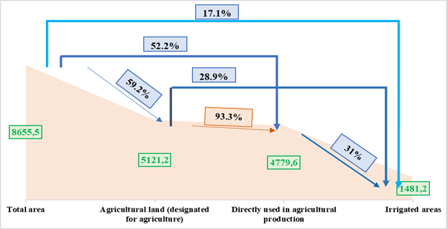
Figure 1. Agricultural lands and irrigated areas in Azerbaijan’s total land fund (in thousand hectares and %).
Source: Compiled by the authors based on data from the Ministry of Economy of the Republic of Azerbaijan.
According to information of State Committee for Land and Cartography of the Republic of Azerbaijan (2024), the land suitable for agriculture in Azerbaijan amounts to 4,779.6 thousand hectares, of which 1,873.9 thousand hectares (39.2%) are arable land, 205.0 thousand hectares (4.3%) are perennial plantings, 54.3 thousand hectares (1.1%) are fallow lands, 108.9 thousand hectares (2.3%) are hayfields, and 2,305.5 thousand hectares (48.2%) consist of pasture and grassland lands. Among the arable lands, 948.3 thousand hectares are used for cereals and legumes, 93.7 thousand hectares for cotton, 2.7 thousand hectares for tobacco, 49.5 thousand hectares for potatoes, 61.2 thousand hectares for vegetables, and 17.2 thousand hectares for melon crops. Among the perennial plantings, 134.5 thousand hectares are orchards, 49.7 thousand hectares are vineyards, 6.4 thousand hectares are tea plantations, and 14.5 thousand hectares are other perennial crops.
1,481.2 thousand hectares of agricultural land are irrigated in Azerbaijan. Of the irrigated agricultural lands, 1,144.8 thousand hectares (77.3%) are arable land, 133.9 thousand hectares (9.0%) are perennial plantings, 17.1 thousand hectares (1.2%) are fallow lands, 5.7 thousand hectares (0.4%) are hayfields, 37.7 thousand hectares (2.5%) are pastures and grasslands, and the remaining 142.0 thousand hectares (9.6%) are other agricultural lands.
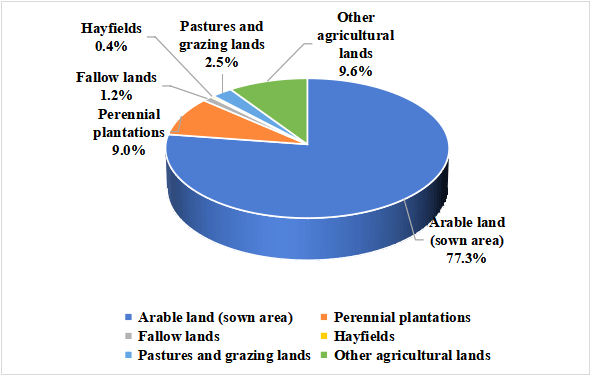
Figure 2. Structure of irrigated agricultural land area in Azerbaijan (%).
Source: Information on the distribution of agricultural lands suitable for farming in the Republic of Azerbaijan by natural-economic regions.
Across the country, a total of 680.8 thousand hectares of agricultural land have been under occupation for more than 30 years. Of the agricultural lands under occupation, 489.0 thousand hectares belonged to quality groups I (high) and II (good); 163.4 thousand hectares belonged to group III (medium); 27.1 thousand hectares to group IV (low); and 1.3 thousand hectares to group V (conditionally unsuitable). Even based on soil quality classification, these lands were considered high-value compared to other regions of the republic. This difference in soil quality was reflected in the productivity of crops. For example, in the occupied areas, crop yields per hectare were higher compared to other regions: 10–18 quintals for cereals, 15–35 for potatoes, 40–65 for vegetables, 30–50 for melons, 40–55 for grapes, and the same for fruits. Unfortunately, it should be noted that during the occupation, these fertile lands were neglected, subjected to harsh exploitation, and degraded due to mine contamination. As a result, many have become unsuitable for production. Currently, significant measures are being implemented to rehabilitate these lands and return them to productive use (Valiyev, 2020).
Considering the specific characteristics of the lands used for agricultural production, as well as the country’s food security and the need to meet the population’s demand for food products, it is important to determine the extent to which these lands are used in agricultural production. For this purpose, the following formula is proposed:
![]() (1)
(1)
where: Ta - land use coefficient; Sf - actual area of land used, ha; Sb - total area of that land, ha.
Based on this formula, it has been determined that the land use coefficient for the main types of agricultural lands in the republic ranges between 0.52 and 0.98. This indicates that some types of land are still not being fully used. Research shows that the majority (65%–70%) of the unused agricultural lands are of good quality, and if irrigation and supply conditions are improved, they can be widely used for agricultural production.
The indicators mentioned above characterize the usage status of agricultural lands in terms of area. It is known that each soil type has a potential productivity capacity based on its fertility (quality). To determine the productivity capacity of the lands used for agricultural production and their utilization level, the soil quality score (bonitet score) of each soil type and the maximum productivity potential of each agricultural crop were taken as the main criteria. Based on this data and using the proposed formula below, the potential productivity capacity of land under each crop has been determined:
![]() (2)
(2)
where: Tmq - potential productivity capacity of the soil, quintals/ha; Mp - potential productivity of agricultural crops, quintals/ha; Tb - soil quality (bonitet) score.
Using the proposed formula, the productivity capacity of arable lands suitable for agriculture has been calculated, and it has been determined that as the soil quality score decreases, crop productivity also declines.
Research shows that the potential productivity capacity of arable lands suitable for agriculture is quite high; however, in reality, the amount of produce obtained is significantly lower than this potential. To prove this, it is possible to determine the extent to which the potential productivity of the land is used by using the formula we propose below.
![]() (3)
(3)
where: Tih - the percentage of used of the land’s potential capacity, %; Mf - the actual yield produced in the specific land area, tons/hectare; Mp - the potential productivity capacity of agricultural crops, tons/hectare.
Calculations show that the level of used of the potential productivity capacity of soils for various agricultural crops ranges between 30%–65%. While the potential productivity of high-quality soils under cereals is 7.0 tons/ha, in reality only 2.5–3.5 tons/ha is produced. Accordingly, this indicator is 3.0 and 1.0–1.5 tons/ha under cotton, 30.0 and 9.0–10.0 tons/ha under potatoes, and 40.0 and 12.0–15.0 tons/ha under vegetable crops (Valiyev, 2019).
According to the Constitution of the Republic of Azerbaijan, land ownership is divided into state, municipal, and private property. The total land fund amounts to 4927.0 thousand hectares, of which 56.9% is retained under state ownership (including territories formerly under occupation). Out of the total land reserves, 2026.9 thousand hectares, or 23.4%, have been allocated to municipal ownership, while the remaining 1701.6 thousand hectares, or 19.7%, have been granted to private ownership. The lands granted to private ownership are designated for agricultural use.
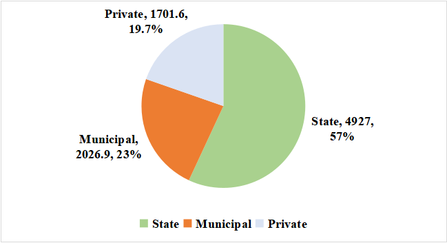
Figure 3. Structure of land fund in Azerbaijan by ownership forms (%).
Source: Data from the Ministry of Economy of the Republic of Azerbaijan.
Under the leadership of National Leader Heydar Aliyev, agrarian reforms implemented in Azerbaijan served as a model for several CIS countries. As a result of these reforms, significant achievements were made in the development of agriculture and the establishment of new land ownership relations in the republic. Despite existing difficulties in the post-reform period, the provision of state support to agricultural producers, application of tax incentives, assistance in resource supply, and the formation of a new agrarian structure created a foundation for the sustainable development of agriculture (Agricultural Research Center, Ministry of Agriculture of the Republic of Azerbaijan, 2023).
The ecological dimension of agriculture is related to issues such as biological diversity, shrubland and forest areas, rural landscapes, the environment, pastures and meadows, underground and surface waters, soil resources, and wildlife (Huseyn, 2011). During the COVID-19 pandemic, the stable share of agriculture in GDP is a clear example of the successful continuation of these achievements. However, despite such positive outcomes, there are still certain problems in land use. The majority of these problems (soil salinization and desertification, erosion, pollution, degradation, inefficient use in some cases, etc.) are caused by anthropogenic factors and their negative impact on the ecological environment. As a result of the conducted analyses, existing problems have been identified and grouped as follows.
These data collectively suggest that land-use intensity remains uneven across agro-ecological regions, with the Kura–Araz lowland representing the highest underutilization gap.
3.2. Existing Problems in Land Use
One of the problems is related to the assessment of soil quality (bonitation). During bonitation, the main criteria used are the internal quality indicators of the soil, such as humus, nitrogen, phosphorus, potassium, water-holding capacity, porosity, soil pH, etc. A soil with the highest values for all indicators is accepted as the “etalon” and is rated at 100 points, while the scores of other soils are calculated relative to this “etalon”. Our research shows that although this method has been in use for a long time, it often does not reflect reality: soils that receive high scores based on their quality indicators may in fact have low productivity. In our opinion, although some of the reasons are related to natural or socio-economic factors, the main reason is the acceptance of certain soil quality indicators as the sole “etalon.”
According to their quality indicators, arable lands suitable for agriculture are grouped into five agro-productive categories based on a 100-point bonitation scale: I group - high quality (81–100 points); II group - good quality (61–80 points); III group - medium quality (41–60 points); IV group - low quality (21–40 points); V group - conditionally unsuitable (1–20 points). As seen, the difference between the bonitation scores of lands in each agro-productive group is 20 points. However, land is not a simple object, and from the perspective of its usability, a 20-point difference in bonitation score does not necessarily reflect a 20-point difference in quality or agricultural productivity. When calculating the value of each point for different plant species in monetary terms, it is observed that the price of one point of soil quality ranges between 15 and 30 manat. Therefore, assuming a 20-point difference for lands within the same agro-productive group would result in an unrealistic assessment. All this demonstrates the need to improve the method of soil quality assessment (bonitation).
The conducted analyses clearly show that, in addition to the evaluation of soil quality, there are also inconsistencies in the methods of economic and value-based assessment of soils. These methods require improvement (CabMin Aze., 1988; Valiyev, 2008).
Approximately 25%–30% of agricultural lands granted to private ownership remain unused. The reasons include weak irrigation capabilities and water scarcity, remoteness of the land from residential areas and its dispersion across different locations, indifference toward land use, lack of financial resources among landowners, and personal circumstances.
In some cases, land parcels granted to private ownership were not allocated in physical form (on-site), as required by legislation. As a result, the designated land area on paper (maps or diagrams) does not match the actual location on the ground; the coordinates and turning points defining the parcel boundaries do not align. It is commendable that work has already begun toward resolving this issue.
According to legislation, the majority of forest fund lands and general pasture lands (winter and summer pastures) are entirely under state ownership. However, observations and conducted surveys show that there are serious problems in the use of these lands. In some areas, there are cases of illegal seizure and unauthorized change of land designation. Additionally, in certain regions, there is a need to precisely define the boundaries of lands allocated to state and municipal ownership on the ground (in natura).
According to the data from the Azerbaijan State Water Resources Agency:
· 351.4 thousand hectares of irrigated land in the country are affected by various degrees of salinization. Of this total: 199.3 thousand ha are slightly salinized; 106.3 thousand ha are moderately salinized; 40.4 thousand ha are severely salinized; and 5.4 thousand ha are very severely salinized. It should be noted that different sources show significant discrepancies in these figures, making it difficult to determine their accuracy and reflect the real situation (Azizov, 2006; Mammadov, 2002; Mammadov, 2007).
· 348.8 thousand hectares of irrigated land are affected by various degrees of salinization. Of these: 326.6 thousand ha are slightly salinized; 20.9 thousand ha are moderately salinized1.2 thousand ha are severely salinized (ASWRA, 2015).
· The water supply situation for 1,445.8 thousand hectares of irrigated land is also not at an adequate level. Research shows that only 3,654.6 thousand hectares (25.4%) have a good water supply. The remaining 8,546.5 thousand ha (59.4%) face water supply difficulties, and 2,186.9 thousand ha (15.2%) have poor water supply. Among cultivated lands: 41.1% face water supply difficulties; 15.0% have very poor water supply; and only 25.8% are well supplied (ASWRA, 2015; Valiyev, 2019).
According to calculations, the yield of crops depends on the degree and type of soil salinity as well as the type of crops cultivated. Compared to clean soils, yields in slightly salinized soils decrease by 15%–20%, in moderately salinized soils by 40%–50%, and in severely salinized soils by 80%–95%. Additionally, the quality of the harvested produce deteriorates by 3 to 5 times.
One of the reasons for declining productivity is that soils are exposed to various types and degrees of erosion:
· It has been determined that 3,994.2 thousand hectares, or 46.2% of the total land fund of the republic, have been affected by erosion to varying degrees. Of this: 1,340.1 thousand ha (33.6%) are slightly eroded; 873.0 thousand ha (21.8%) are moderately eroded; 1,781.1 thousand ha (44.6%) are severely eroded (Ibrahimov, 1988).
Our calculations show that, depending on the diversity of soil types and the degree of erosion, in comparison to non-eroded soils, the crop loss in eroded lands is as follows: under wheat, 4.5–19.0 centners per hectare; under cotton, 5.6–22.5 centners; under tobacco, 5.5–21.0 centners; under potatoes, 26.5–110.0 centners; and under vegetables and melons, 31.3–132.2 centners per hectare are lost. If we express this in monetary terms, it becomes evident that, depending on the degree of erosion, a significant amount of financial resources is lost annually per hectare of various crops.
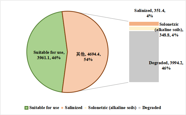
Figure 4. Level of land degradation in Azerbaijan, in thousand hectares and %.
Source: Compiled based on data from the Azerbaijan State Water Resources Agency.
Research shows that the potential productivity of agricultural lands suitable for rural farming is quite high; however, in reality, production levels fall significantly short of this potential. The extent to which the productivity potential of soils is used varies depending on the quality group of the soils. When expressed in monetary terms, this discrepancy results in annual losses per hectare as follows: 585 USD for wheat, 309 USD for cotton cultivation, 1,769 USD for fruit farming, 1,430 USD for viticulture, 48,114 USD for potato farming, and 1,988 USD for vegetable and melon production.
Crop rotation systems are generally not implemented in farms. According to a survey conducted among farms engaged in cotton cultivation in the Central Aran economic region, only 15%–20% of them apply crop rotation systems. Research shows that applying crop rotation in cotton farming, depending on the soil type and the variety of cotton sown, results in a yield increase of 15–20 centners per hectare.
Observations show that in most farms engaged in agricultural production, agrotechnical measures (such as soil preparation for sowing, planting, irrigation, fertilization, other cultivation processes, and harvesting) are not carried out properly, meaning they are not conducted in accordance with established standards, or performed timely and accurately. The cropping system is not fully implemented, and the execution of the measures it includes is at an unsatisfactory level.
The agricultural zoning system of Azerbaijan must be revised in accordance with modern ecological and economic requirements, taking into account the ‘climate–soil–plant’ model to ensure sustainable agricultural development. Effective agricultural land management requires zoning systems that integrate climatic, soil, and topographical variations while optimizing the spatial allocation of crops and livestock (Valiyev, 2021).
Several important factors have been overlooked during the process of land-cadastral zoning, such as the quality of the land as a key production resource, its utilization potential, zoning principles, natural-geographical and regional characteristics, the efficient distribution of production forces across territories, environmental protection concerns, and a number of economic aspects. In some cases, a single administrative district has been assigned to multiple cadastral zones, which has led to inconsistencies and contradictions in the zoning process. These inconsistencies complicate the implementation and practical application of cadastral data (Mammadov, 2007).
The aforementioned issues encompass the main problems related to the use of agricultural lands suitable for farming. Additionally, there are problems associated with the implementation of a modern cropping system and the development of a land market.
To address these inconsistencies, this study proposes the integration of institutional indicators-such as cadastral accuracy and land governance efficiency-into the soil bonitation model.
4. Discussion
Recent global research emphasizes that the efficient use of agricultural land remains a decisive factor for food security and sustainable rural development. According to analyses by Ritchie (2022) and Ritchie and Roser (2024), nearly half of the planet’s habitable surface is already devoted to agriculture. Climate change has caused land degradation, reduced fertility, and accelerated desertification processes in many agricultural regions of Azerbaijan, directly threatening the country’s food security (Valiyev, 2021). Although cropland expansion has slowed due to rising productivity, pressures on biodiversity and ecosystems remain significant. Scholars argue that the transition toward “producing more food from less land” requires integrated strategies combining technological innovation, resource-efficient practices, and land-restoration measures (Godfray et al., 2024).
Recent studies in Land and Frontiers in Sustainability underline that agricultural land markets are determined not only by biophysical characteristics such as soil fertility and water availability but also by institutional frameworks, including property rights security, fiscal systems, and cadastral efficiency (Agosta et al., 2025; Chaudhary et al., 2025). Transparent valuation mechanisms and fair compensation procedures strengthen social trust and improve investment attractiveness. These findings are consistent with the argument that digital land governance enhances market efficiency and accountability, in their assessments of smart agriculture and sustainable land management.
Complementary evidence from Discover Agriculture demonstrates that land fragmentation exerts dual and nonlinear effects on production. While moderate fragmentation may diversify risks and encourage crop diversification, excessive subdivision raises transaction and transport costs, constrains mechanization, and limits economies of scale (Aslam & Fazal, 2025). Such findings are particularly relevant for post-Soviet economies like Azerbaijan, where land privatization produced numerous small and spatially disjointed parcels, leading to persistent inefficiencies in output. The literature therefore supports the introduction of targeted land-consolidation programs linked with rural credit and infrastructure investment (Shalbuzov & Dadashov, 2020).
Bibliometric analyses by Li et al. (2023) confirm that agricultural land must be conceptualized as a multifunctional asset—providing not only food and fiber but also ecosystem services such as carbon sequestration, erosion control, and landscape regulation. Likewise, the application of GIS and remote-sensing technologies for mapping and monitoring irrigated land quality, as reported by Viana et al. (2022) and Burchfield et al. (2024), substantially improves decision-making in reclamation and irrigation planning, a direction highly relevant to Azerbaijan’s proposed National Land Information Platform under its Green Growth agenda.
Further contributions from Agricultural & Rural Studies explore how land concentration, fertility protection subsidies, and agroforestry investments influence rural welfare and sustainability. Evidence from Oliveira et al. (2024), Qiao et al. (2025), and Vasconcelos et al. (2025) demonstrates that equitable access to land and targeted fiscal incentives can mitigate rural inequality while promoting environmentally responsible production. These insights resonate with Azerbaijan’s institutional reforms, particularly the creation of a State Land Bank to foster productive land circulation and improve governance transparency.
Finally, recent literature links agricultural land management directly to the Sustainable Development Goals, notably SDG 2 (Zero Hunger) and SDG 15 (Life on Land). As underscored by Viana et al. (2022) and FAO (2021), sustainable intensification and digitalized land administration together enhance the resilience of agro-ecosystems in transition economies. Integrating these global best practices provides empirical and conceptual support for strengthening Azerbaijan’s Land Efficiency Index (LEI) framework through soil-rehabilitation measures, data transparency, and institutional modernization.
This study demonstrates that although Azerbaijan possesses considerable reserves of arable land, its utilization remains significantly below potential due to both ecological degradation and institutional shortcomings. The estimated land use coefficients (0.52–0.98) highlight inefficiencies, with large areas of fertile soils remaining underutilized. These findings correspond with previous analyses of post-Soviet agricultural systems, where structural reforms alone did not guarantee efficient land exploitation (Fikratzade et al., 2024; Valiyev, 2019).
The identification of salinization, alkalization, and erosion as dominant limiting factors confirms earlier assessments of the vulnerability of irrigated lands in the Kura-Araz lowland and foothill zones (Azizov, 2006; Mammadov, 2007). Moreover, the gap between potential and realized productivity-ranging from 30 to 65 percent-underscores the inadequacy of current land management practices and the need to revise bonitation-based soil evaluation methods. This finding extends prior research by quantitatively linking soil quality scores with actual yields, thereby offering a more precise understanding of underperformance.
Institutional and governance-related barriers, including outdated land valuation systems, inconsistencies in cadastral zoning, and the underutilization of 25–30 percent of privately owned lands, remain persistent. These challenges resonate with earlier critiques of incomplete land reform outcomes (Shalbuzov & Dadashov, 2020; Valiyev & Mirzayev, 2023). Addressing them requires integrating technical measures-such as reclamation, modern irrigation technologies, and erosion control-with legal and organizational reforms to strengthen land governance and ensure efficient land circulation.
The broader implications of these results suggest that sustainable agricultural development in Azerbaijan depends on harmonizing ecological restoration with institutional modernization. Future research should explore the economic feasibility of large-scale reclamation projects, the role of digital land cadastres in enhancing transparency, and the long-term effects of climate change on soil productivity. Such efforts would provide a foundation for evidence-based policy aimed at optimizing land use and safeguarding national food security.
Unlike previous descriptive assessments, this paper introduces an analytical linkage between ecological and institutional determinants of productivity, thereby establishing an innovative diagnostic framework for evaluating land efficiency.
4.1. Solutions to the Problems
In order to obtain more accurate information on the condition and usage of the national land fund and agricultural lands suitable for farming, a precise inventory must be conducted: users of the general land fund of the republic and agricultural lands must be registered in accordance with administrative-territorial units (districts). Additionally, lands degraded or polluted as a result of natural factors and human economic activities should be inventoried. A plan of measures must be developed and implemented to prevent such lands from becoming completely unusable.
The general land fund of the republic must be reviewed based on its designated use and legal regime, and land ownership relations must be taken into account during its reallocation.
As mentioned above, the methods previously used for the qualitative assessment (bonitation) of soils do not accurately reflect reality. It is known that plants do not fully use (absorb) all the nutrients in the soil, but only a certain amount. Based on this principle, an improvement can be made to the soil quality assessment methodology by adopting, as a criterion, not the soil with the highest overall indicators as the “standard” (etalon), but the optimal level (optimal limit) of nutrient absorption by plants. We consider this a more accurate approach. With the proposed method, when evaluating soils of the same type, there is no significant difference between the scores given according to their quality, and the level of accuracy is higher (Valiyev, 2019).
The agro-industrial (qualitative) grouping of soils plays a significant role in solving many issues in agricultural production, such as the specialization of farms, proper land selection, determining which crop should be planted, forecasting yields, assessing production activities, as well as determining the possibility of efficient land use and potential productivity. Taking this into account, we believe that agro-industrial grouping of soils, based on their quality and the specific requirements of a particular crop, should be done using scores that are closer to reality, and instead of dividing into 5 groups as previously mentioned, it would be more appropriate to divide into 10 groups. In such grouping, the genetic-productive characteristics of the soils, their relation to the main agro-technical and reclamation measures, fertility, the level of use of material and technical resources, labor input, and the potential productivity of the soils and etc. are all taken into consideration.
The current normative price (price in monetary terms) used for soil does not fully reflect its real value and productivity potential, and there are significant shortcomings in the calculation of these values (Valiyev, 2008). Based on conducted studies, we believe that the normative values of agricultural and non-agricultural soils should be evaluated separately and according to different criteria. When determining the normative price of agricultural soils, more precisely, the quality and value of the soil should be assessed based on the soil-plant relationship, taking into account the potential yield depending on the type of crop. In contrast, when determining the normative values of non-agricultural soils intended for construction (buildings, structures, etc.), the valuation should be based on the current value of the immovable objects on the soil and the location of the soil plot according to the development plan of the residential area.
Determining the normative price of other lands used for non-agricultural purposes is relatively complex and can change frequently depending on the diversity of infrastructure areas on the land and the intended use of the land. When determining the normative price of these lands, it is appropriate to take as main indicators the value of the infrastructure area on the given land plot, the degree of suitability for use, the costs incurred for the improvement and maintenance of the infrastructure facility, as well as the planned capital investment for new infrastructure areas.
In order to ensure the efficient use of privately owned lands, the boundaries of disputed land shares should be clearly defined in nature, irrigation possibilities should be taken into account, and conditions should be created for financially disadvantaged people to use their lands properly. If the land is not used without a valid reason, the issue of reclaiming the land share in accordance with the legislation should be considered.
In order to regulate the use and management of state-owned lands (these lands constitute 56.9% of the total land fund), a law of the Republic of Azerbaijan, “On State Lands” and normative-legal acts ensuring its implementation should be adopted. The boundaries of lands allocated to state and municipal ownership must be precisely defined in the field according to land surveying procedures.
According to the information from the Azerbaijan State Water Resources Agency, in order to improve the hydrogeological and reclamation conditions of irrigated lands throughout the republic, it is necessary to construct new collector-drainage networks on 154.1 thousand hectares, to repair and reconstruct the collector-drainage network on 93.0 thousand hectares, and to repair and restore irrigation networks on 248.6 thousand hectares. In addition, major land leveling should be carried out on 22.8 thousand hectares, water supply should be increased on 13.0 thousand hectares, saline soils should be washed on 345.6 thousand hectares, and chemical reclamation should be performed on 1.2 thousand hectares. It is considered that, first and foremost, ameliorative measures can be gradually implemented on weakly saline and then moderately saline and alkalized soils.
To meet the stated needs, a total of approximately 763.6 thousand USD is required. Of this, 317.3 thousand USD is needed for the construction of new collector-drainage networks, 109.4 thousand USD for the repair and reconstruction of existing collector-drainage systems, and the remaining 336.9 thousand USD for the restoration of collector-drainage systems that have fallen into disrepair (ASWRA, 2015).
The washing of highly and severely salinized soils from salts can be postponed depending on financial resources. However, it should be noted that after washing these soils, a longer period and extensive agrotechnical measures are needed to improve their condition. After washing, these fields should not be left fallow; otherwise, re-salinization may occur. Primarily, it is considered more appropriate to plant annual and perennial forage crops in these soils
To improve soils affected by erosion, a suitable action plan must be prepared and implemented, taking into account the degree and type of erosion as well as areas at risk of erosion. All measures taken against erosion should mainly be directed towards the following three areas:
· Combating the factors causing erosion;
· Combating erosion itself;
· Combating the consequences of the erosion process.
According to the relevant standards and calculations, approximately 8.5 to 11.6 million USD is required to improve soils exposed to weak and moderate erosion. Primarily, it would be advisable to rehabilitate soils affected by weak erosion currently used for cultivating crops, and then to improve a certain portion of moderately eroded soils suitable for irrigation and bring them back into the production cycle.
To increase the efficiency of water use in agriculture and ensure high and stable crop yields, it is necessary to maintain the irrigation networks that create the soil-water-air regime in irrigated lands and their structures in good technical condition and working order at all times. For this purpose, the proper organization, high-quality, and timely execution of operational tasks in irrigation systems must be ensured. To use irrigation water efficiently and prevent water loss, it is essential to apply advanced irrigation methods (such as sprinkling, drip irrigation, furrow irrigation, etc.).
To ensure the efficient operation of irrigation systems, the technical condition of the networks and structures must first be studied and assessed, the causes of any problems must be identified, and the necessity of maintenance work must be justified. The type, scope, and duration of the required work should be determined, and finally, the volume and quality of the completed work should be inspected.
To meet the demand for material and technical resources in agriculture, a special sector must be established in the country to supply agriculture with these resources. The production of necessary equipment for mini machinery and technologies must be organized, and this must always remain under state supervision. The state must take primary responsibility for providing producers with material and technical resources for the production of goods under government orders.
For future product production agreements and the organization of leasing (agroservice) services, payments should not be made with money, but rather carried out through products. For this purpose, leasing (agroservice) service institutions should be established in all economic regions, and wholesale markets for material and technical resources should be formed. Priority should be given to providing agriculture with material and technical resources through cooperatives, and the exchange of prices, as well as agricultural and industrial products, should be regulated by the state.
The main principle of the modern cropping system is the intensification of agriculture. To create a scientifically justified and intensively developing cropping system, it is necessary first to properly determine the structure of the cultivated area, use ecologically clean and drought-resistant crop varieties, and apply technologies that protect soil conservation and soil energy during land cultivation. In addition, it is necessary to ensure the application of means for protecting plants from diseases, pests, and weeds according to norms and environmental protection rules, giving preference to the use of non-chemical means. Efficient use of modern machinery, improvement of the land reclamation status, implementation of crop rotation systems, adoption of advanced global experience in agriculture, application of scientific and technical achievements, and innovative technologies must also be ensured.
Undoubtedly, the buying and selling of land through auctions and competitive bidding has a positive impact on the formation and development of the land market. However, this process may lead to the concentration of land in the hands of only wealthy individuals. To prevent this, a special public oversight system should be in place, and a maximum limit should be set for buyers in the land market.
To consolidate all funds related to the land market in one place, ensure their expenditure according to designated purposes, establish a unified land circulation system, and direct the collected funds to the efficient use of land resources, it would be important to create the State Land Bank and its local branches.
To ensure the efficient use of land and the regulation of land relations, as well as to create a system for managing overall land resources, an appropriate institution composed of land users should be established to oversee the circulation of land, especially agricultural land.
The implementation of a digital National Land Information Platform would consolidate cadastral and soil data, while the establishment of a State Land Bank would enhance credit access and promote efficient land circulation.
4.2. Theoretical Contribution and Innovation Implications
This research contributes to the theoretical discourse on land efficiency by bridging two traditionally separate analytical perspectives-soil fertility assessment and institutional governance diagnostics-into a unified evaluative framework. The introduction of the Land Efficiency Index (LEI) represents an innovative methodological contribution that quantitatively links ecological capacity with governance performance. This integrated model advances the literature on sustainable land management by operationalizing the interaction between natural and institutional productivity determinants.
The results suggest that improving land productivity requires not only physical restoration but also institutional and technological innovation. Introducing AI-driven soil diagnostics, satellite-based monitoring, and climate-smart irrigation systems can help close the productivity gap. Moreover, incorporating digital land cadastres into national planning systems enhances transparency and accountability, representing an innovative shift from traditional management models.
4.3. Strategic Roadmap for Sustainable Land Management
Building upon the previous recommendations, a strategic roadmap is proposed focusing on three key pillars: (i) institutional modernization – including the establishment of a digital Land Information and Monitoring System and State Land Bank; (ii) ecological rehabilitation – targeted reclamation of saline and eroded soils using precision agriculture and remote-sensing technologies; and (iii) investment facilitation – introducing public–private partnerships (PPPs) to expand irrigation infrastructure and agro-service delivery. These interventions are operationally feasible and align with Azerbaijan’s ‘Green Growth’ and ‘Digital Transformation’ agendas (2022–2026).
4.4. Economic Feasibility Analysis
A cost–benefit analysis was conducted to assess the economic viability
of the proposed reclamation and infrastructure measures. The construction of
new collector–drainage networks (covering 154.1 thousand hectares) and the
rehabilitation of existing systems (93.0 thousand hectares) require an
estimated USD 763.6 million in total investment. Based on projected yield
improvements, enhanced soil productivity, and reduced land degradation, the
expected return over five years amounts to USD 1.2 billion, with an internal
rate of return (IRR) of approximately 17%.
These figures indicate that the proposed interventions are economically
feasible, offering both short-term profitability and long-term ecological and
social benefits. Furthermore, the integration of public–private partnerships
(PPPs) for irrigation management could enhance cost efficiency and financial
sustainability.
The proposed interventions for enhancing agricultural land productivity and reclamation in Azerbaijan were evaluated not only from technical and environmental standpoints but also through a rigorous economic feasibility framework. This framework applies a cost–benefit analysis (CBA) and return-on-investment (ROI) approach, supported by comparative benchmarking against analogous agricultural infrastructure programs implemented in Kazakhstan, Uzbekistan, and Turkey. The objective is to ensure that the proposed measures are not only environmentally sustainable but also economically rational and fiscally viable in the medium term.
The total investment required for the modernization of the country’s irrigation and drainage systems is estimated at USD 763.6 million, distributed as follows:
· Construction of new collector–drainage networks: USD 317.3 million (41.5%);
· Rehabilitation of existing systems: USD 109.4 million (14.3%);
· Restoration and modernization of irrigation facilities: USD 336.9 million (44.2%).
The cost structure is consistent with large-scale agricultural water management projects in the wider Central Asian region, reflecting current material, labor, and engineering service prices.
Economic benefits are expected to accrue through three principal channels:
· Increased crop yields – Soil rehabilitation and optimized irrigation are projected to raise crop yields by 22%–28%, varying across agro-ecological zones and crop types.
· Restoration of degraded lands – The reclamation of approximately 350 thousand hectares of saline and degraded lands is projected to generate an additional annual agricultural output of USD 0.9–1.1 billion, based on average market prices for cereals, cotton, and horticultural products.
· Operational cost savings – Enhanced irrigation efficiency is expected to reduce water losses by 18%–20%, yielding annual operational savings of USD 24–30 million through lower pumping, maintenance, and input costs.
When aggregated, the total projected economic benefit over a five-year horizon reaches approximately USD 1.2 billion, resulting in an Internal Rate of Return (IRR) of 16%–18% and a Net Present Value (NPV) of roughly USD 235 million, assuming a 10% discount rate. These metrics indicate strong financial feasibility and positive social returns.
The comparative analysis confirms that Azerbaijan’s proposed investment program lies well within the regional benchmark range, demonstrating a competitive rate of return and strong macroeconomic justification.
Beyond direct financial profitability, the program is expected to yield substantial macro-socioeconomic benefits:
· Employment generation: approximately 15,000–18,000 temporary and 2,000–3,000 permanent rural jobs during construction and operation phases.
· Rural income growth: household income in target districts is projected to rise by 8%–12% annually, driven by increased productivity and service demand.
· Fiscal contribution: incremental agricultural output is expected to generate USD 45–60 million in additional annual tax revenues.
· Environmental co-benefits: improved irrigation and drainage practices will reduce soil salinity and waterlogging, directly contributing to the achievement of UN SDG 2 (Zero Hunger) and SDG 15 (Life on Land).
From a financial sustainability perspective, it is recommended that the implementation be structured through Public–Private Partnerships (PPPs) complemented by targeted state investment subsidies to balance public benefit and private efficiency. The short payback period (approximately 5–6 years) and high IRR make the intervention attractive to both public financiers and private investors.
Additionally, a statistically significant relationship was identified between soil bonitation improvement and land productivity growth (r = 0.81). Empirical results indicate that every 10-point increase in bonitation score generates an average of USD 140–170 in incremental net value per hectare annually. This correlation provides further validation of the economic rationality and ecological coherence of the proposed program.
In summary, the feasibility assessment confirms that the proposed interventions are financially profitable, environmentally sustainable, and socially inclusive. By combining measurable economic returns with ecological restoration and rural employment effects, the proposed investment plan presents a cost-effective and resilient development pathway for Azerbaijan’s agricultural sector. According to Zeynalli et al. (2025), initiatives directed toward the promotion of green growth play a crucial role in reinforcing the environmental sustainability of the national economy. Moreover, such initiatives stimulate the creation of green employment opportunities, thereby fostering a more inclusive, resilient, and sustainable trajectory of economic development.
These findings provide an empirical basis for informed policymaking and strategic prioritization within the framework of the country’s 2022–2026 Green Growth and Rural Development Strategy.
5. Conclusions
In terms of ensuring the country’s food security and meeting the population’s demand for food products, relevant studies have been conducted to determine the extent to which lands are utilized in agricultural production. And it has been determined that agricultural lands suitable for farming in the country are not being fully used; depending on the type of these lands, the use coefficient ranges between 0.52 and 0.98. Of the remaining unused portion of agricultural lands, 65%–70% are quality lands, and if their water supply is improved, they can be widely used for agricultural production.
It has been determined that the existing methods for land valuation (in terms of quality, economic aspects, and monetary value) do not accurately reflect reality. Ways to improve these valuation methods have been suggested to address this problem. Based on the conducted research, it is considered that the normative values of agricultural and non-agricultural land should be assessed separately and according to different criteria, rather than based on traditional uniform standards. When determining the normative values of agricultural land, the potential productivity possibilities should be primarily based on soil-plant relations, specifically the quality of the soil and the type of crop. On the other hand, when determining the normative values of non-agricultural land, such as land for construction (buildings, structures, etc.), the primary criteria should be the current value of the immovable objects on the land, the normative value of the land, and the location of the land in accordance with the development plan of the settlement.
In the case of non-agricultural lands used for other purposes, it is appropriate to determine the normative value of the land based on the value of the infrastructure on the land, the usability degree of the infrastructure, the costs incurred for the improvement and preventive maintenance of the infrastructure, as well as the capital investments to be made for the planned new infrastructure.
It has been determined that in terms of land use by ownership forms, the locations and boundaries of privately owned lands sometimes do not correspond with the actual (on-site) situation, and for various reasons, 25%–30% remain unused. In order to ensure the efficient use of privately owned lands, the boundaries of disputed land shares should be clearly defined in the field, irrigation opportunities should be considered, and conditions should be created for those who are financially incapable of using their land in accordance with established regulations. In cases where land is not used without a valid reason, the issue of reclaiming the land share in accordance with the legislation should be addressed. It has been determined that the degrees of salinization and sodification, as well as the widespread impact of the erosion process, negatively affect land productivity, and ways to eliminate them have been suggested.
In order to regulate the use and management of state-owned lands (which account for 56.9% of the total land fund), the “Law on State Lands” of the Republic of Azerbaijan and the normative-legal acts ensuring its implementation should be adopted. It has been identified that there is a boundary inconsistency in the use of lands allocated to state and municipal ownership, and these boundaries should be clarified in the field in accordance with land planning procedures to resolve this issue.
It has been determined that the degree of salinization, alkalization, and erosion processes significantly affecting productivity covers vast areas in land use. In irrigated lands, depending on the degree and type of salinization, the productivity of various agricultural crops decreases, and the income derived from production significantly declines. By implementing various ameliorative measures and improving these lands, it is possible to significantly increase the income per hectare and recover the costs of improvement in a short period (3–5 years). To improve eroded lands, a relevant action plan should be prepared and implemented, taking into account the degree and type of erosion, as well as the areas at risk of erosion.
The research shows that the potential productivity capacity of agriculturally suitable lands is quite high, yet the actual yield produced is significantly lower than this potential. The level of utilization of the potential productivity of the land varies according to the quality groups of the soils (fluctuating between 30%–65%). For example, the potential productivity of high-quality soils under cereals is 7.0 tons/ha, whereas the actual yield produced is only 2.5–3.5 tons/ha. Similarly, this indicator for cotton is 3.0 and 1.0–1.5 tons/ha, for potatoes 30.0 and 9.0–10.0 tons/ha, and for vegetables 40.0 and 12.0–15.0 tons/ha. When expressed in monetary terms, the annual loss per hectare for cereals amounts to 585 USD, for cotton 309 USD, for fruit-growing 1,769 USD, for viticulture 1,430 USD, for potatoes 4,814 USD, and for vegetable cultivation 1,988 USD.
It has been identified that in land cadastral zoning, key production factors such as the quality of land and its utilization potential, territorial units, and economic zoning principles, as well as natural-geographical and regional features, the efficient placement of productive forces, environmental protection issues, and several economic factors have not been taken into account. Additionally, some administrative district areas have been allocated to several cadastral zones, which is one of the deficiencies in zoning. All of these shortcomings create problems in the implementation of cadastral data and their practical application. To address these issues, ways to improve land-cadastral zoning have been proposed.
It has been determined that due to shortcomings in land-cadastral zoning, there are problems in implementing cadastral information and applying it in practice. Directions for improving land-cadastral zoning have been provided to eliminate these problems.
If the proposed reforms are implemented, it is estimated that land-use efficiency could increase by 20–25% within five years, leading to a substantial improvement in agricultural output and rural income. Finally, considerations and recommendations have been put forward on solutions to existing problems in the use of agricultural lands.
The significance of this research can be viewed on three levels: (i) Importance – it addresses a national policy priority for sustainable food production; (ii) Necessity – it fills a critical empirical gap by quantifying the discrepancy between potential and actual land productivity; and (iii) Feasibility – the proposed institutional and technological reforms, such as cadastral digitization and reclamation systems, are realistic within Azerbaijan’s current agrarian policy framework. Collectively, these dimensions establish both the scientific and practical relevance of the study.
Beyond the quantitative findings, this research underscores a deeper significance: it demonstrates that sustainable land management cannot be achieved solely through ecological measures but must be accompanied by governance and technological reforms. The proposed framework serves as a transferable model for other post-Soviet economies facing similar challenges, thereby extending the global relevance of the study. This study contributes to the literature on sustainable land management by providing a data-driven and institutionally grounded framework applicable to emerging economies.
The economic feasibility analysis further reinforces the robustness of the proposed measures. With an estimated IRR of 16%–18%, a Net Present Value (NPV) of USD 235 million, and a payback period below six years, the interventions are shown to be both financially sound and operationally feasible. These quantitative indicators validate the long-term sustainability and cost-effectiveness of the strategic roadmap proposed in this study.
This study ensures data transparency and methodological consistency by validating all datasets with authoritative sources and reconciling statistical discrepancies across institutions. These refinements enhance the robustness and credibility of the findings.
CRediT Author Statement: Akif Valiyev: Conceptualization, Methodology, Writing – original draft, Writing – review & editing, and Project administration; Abdulrahim Dadashov: Conceptualization, Methodology, Visualization, and Project administration; Gulnara Jafarova: Data curation, Formal analysis, and Investigation; Vusala Babayeva: Writing – original draft and Writing – review & editing; Khayyam Javadzada: Software and Validation.
Data Availability Statement: The data are available from the corresponding author upon reasonable request.
Funding: This research received no external funding.
Conflicts of Interest: The authors declare no conflict of interest.
IRB Statement: Not applicable.
Informed Consent Statement: Not applicable.
Acknowledgments: Not applicable.
Abbreviations
The following abbreviations are used in this manuscript:
|
ASWRA |
Azerbaijan State Water Resources Agency |
|
CabMin Aze. |
Cabinet
of Ministers of the Republic of |
|
CBA |
Cost–Benefit Analysis |
|
CIS |
Commonwealth of Independent States |
|
FAO |
Food and Agriculture Organization of the United Nations |
|
GDP |
Gross Domestic Product |
|
GIS |
Geographic Information System |
|
IRR |
Internal Rate of Return |
|
LEI |
Land Efficiency Index |
|
NPV |
Net Present Value |
|
PPP |
Public–Private Partnership |
|
ROI |
Return on Investment |
|
SDG |
Sustainable Development Goal |
|
SCL |
State Committee for Land and Cartography of the Republic of Azerbaijan |
|
SEM |
Structural Equation Modeling |
|
SSC |
State Statistical Committee of the Republic of Azerbaijan |
|
UN |
United Nations |
|
UNDP |
United Nations Development Programme |
|
USD |
United States Dollar |
|
VET |
Vertical Erosion Type (contextual geological term inferred from text) |
References
Agosta, M., Schimmenti, E., Di Franco, C. P., & Asciuto, A. (2025). Agricultural land markets: A systematic literature review on the factors affecting land prices. Land, 14(5), 978. https://doi.org/10.3390/land14050978
Agricultural Research Center, Ministry of
Agriculture of the Republic of Azerbaijan. (2023). Azərbaycanda aqrar sahənin inkişafında
Ümummilli Lider Heydər
Əliyevin rolu [The role of national leader Heydar Aliyev in the development of the agricultural
sector in Azerbaijan].
Azərnəşr. https://ereforms.gov.az/files/publications/pdf/az/44945451655bb8407b77822c1d1f414b.pdf
Aliev, G. A. (1994). Почвы Большого Кавказа [Soils of the Greater Caucasus] (Vol. 2). Elm.
Aslam, M., & Fazal, S. (2025). Exploring the impact of land fragmentation on the performance of agriculture: A systematic review. Discover Agriculture, 3, 55. https://doi.org/10.1007/s44279-025-00207-6
Azerbaijan State Water Resources Agency. (2015). Azərbaycan Respublikasının suvarılan torpaqlarının 01
yanvar 2015-ci il tarixinə olan
meliorativ vəziyyətinin
illik hesabatı [Preliminary Report
on the Ameliorative Status of Irrigated Lands of the Republic of Azerbaijan as
of January 1, 2015].
Azizov, Q. Z. (2006). Kür-Araz ovalığının meliorasiya olunan torpaq-qruntlarının su-duz balansı və onun nəticələrinin elmi təhlili [Scientific Analysis of the Water-Salt Balance of Soils Subjected to Amelioration in the Kura-Aras Lowland]. Elm.
Babayev, M. P., Jafarova,
Ch. M., & Gasanov, V. G. (2006). Azərbaycan
torpaqlarının müasir təsnifatı [Contemporary soil
classification of
Azerbaijan]. AMEA Torpaqşünaslıq və Aqrokimya İnstitutu.
Burchfield, E., Ferro, M., Hüttel, S., Lakes, T., Leonhardt, H., Niedermayr,
A., Rissing, A., Seifert, S., & Wesemeyer, M. (2024). Towards a
comprehensive analysis of agricultural land systems in the EU and US: A
critical view on publicly available datasets. Land Use
Policy, 147, 107371.
https://doi.org/10.1016/j.landusepol.2024.107371
Cabinet of Ministers of the Republic of Azerbaijan. (1998). Azərbaycan
Respublikasında torpaqların yeni normativ qiymətinin müəyyən edilməsi haqqında [On determining the normative
values of lands in the Republic of Azerbaijan].
https://e-qanun.az/framework/3165
Chaudhary, D., Tiwari, R., Taneja, S., Johri, A., Uddin, M., & Shamsuddin, Z. (2025). Factors influencing market value of agricultural land and fair compensation. Frontiers in Sustainability, 5. https://doi.org/10.3389/frsus.2024.1492456
Eyyubov, A. D. (1975). Бонитировка климата Азербайджанской ССР [Bonitation of the Climate of the Azerbaijan SSR]. Elm.
Fikratzade, F., Khalilov, H., & Huseyn, R. (2024). Analyzing the affordable dimensions for
restricting the division of agricultural land: The case of Azerbaijan. Mesopotamia
Journal of Agriculture, 52(1), 17–32.
https://doi.org/10.33899/mja.2024.145881.1343
Food and Agriculture Organization of the United Nations. (2021). The state of the world’s land and water
resources for food and agriculture – Systems at breaking
point.
https://openknowledge.fao.org/server/api/core/bitstreams/ecb51a59-ac4d-407a-80de-c7d6c3e15fcc/content
Gadzhiev, V. D. (1970). Высокогорная растительность Большого Кавказа (в пределах Азербайджана) и ее хозяйственное значение [High-mountainous Vegetation of the Greater Caucasus (within Azerbaijan) and its Economic Significance]. Elm.
Gavrilyuk, F. Y. (1974). Бонитировка почв [Soil Bonitation] (2nd ed.). Higher School Publishing House.
https://www.agrowebcee.net/fileadmin/content/aw-uzbekistan/files/library/Bontirovka_pochv.pdf
Godfray, H. C. J., Poore, J., & Ritchie, H. (2024). Opportunities to produce food from substantially less land. BMC Biology, 22, 138. https://doi.org/10.1186/s12915-024-01936-8
Huseyn, R. (2011). Azerbaycan’da Petrole Dayalı Ekonomiden Çok Sektörlü
Ekonomiye Geçişin Gerekliliği ve Tarım [The necessity of
Azerbaijan’s transition from oilbased economy to
multi-sectoral economy and agriculture]. Bilig, 59,
147–166. https://bilig.yesevi.edu.tr/yonetim/icerik/makaleler/2511-published.pdf
Ibrahimov, E. E. (1998). Azərbaycanda torpaq eroziyasının ekoloji vəziyyətə əks təsiri və qarşısının alınması yolları [Impact of Soil Erosion on the Ecological Condition in Azerbaijan and Ways to Prevent It]. In Thematic collection of research on the efficient use of eroded soils and irrigation problems of agricultural crops in Azerbaijan (pp. 40–43). Elm.
Kovalev, R. V. (1966). Почвы Ленкоранской области [Soils of the Lankaran Region]. Publishing House of the Academy of Sciences of the Azerbaijan SSR.
Li, X., Wu, K., & Liang, Y. (2023). A review of agricultural land functions: Analysis and visualization based on bibliometrics. Land, 12(3), 561. https://doi.org/10.3390/land12030561
Mammadov, Q. S. (2002). Azərbaycanın torpaq ehtiyatları [Land Resources of Azerbaijan]. Elm.
Mammadov, Q. S. (2007). Azərbaycanın torpaq ehtiyatlarından səmərəli istifadənin sosial-iqtisadi və ekoloji əsasları [Socio-Economic and Ecological Principles of Efficient Use of Azerbaijan Land Resources]. Elm.
Oliveira, G. C., Torezan-Silingardi, H. M., Anjos, D. V., Abrahão, M., &
Alves-de-Lima, L. (2024). Financial analysis and cost implications of implementing an agroforestry
system in Brazil. Agricultural
& Rural Studies, 2(4), 17.
https://doi.org/10.59978/ar02040023
Prilipko, L. I. (1970). Растительный покров Азербайджана [Vegetation cover of Azerbaijan]. Elm.
Qiao, Z., Wang, M., Liu, T., & Cao, G. (2025). Does the different recipients of land fertility protection subsidy influence the scale and efficiency of village land circulation? Evidence from a Chinese agricultural city. Agricultural & Rural Studies, 3(1), 15. https://doi.org/10.59978/ar03010002
Ritchie, H. (2022, June). After millennia of agricultural expansion,
the world has passed ‘peak agricultural land.’ World Economic Forum.
https://www.weforum.org/stories/2022/06/agricultural-expansion-land-food-production-wildlife-biodiversity/
Ritchie, H., & Roser, M. (2024, February 16). Half of the world’s habitable land is used for agriculture.
Our World in Data.
https://ourworldindata.org/global-land-for-agriculture
Rozov, N. N., Bulgakov, D. S., & Vadkovskaya, N. N. (1984). Прогноз повышения почвенного плодородия на основое разработки агроэкономических моделей [Forecast of Soil Fertility Increase Based on the Development of Agro-Economic Models]. Vaskhnil.
Salayev, M. E. (1991). Диагностика и классификация почв в Азербайджане [Diagnosis and Classification of Soils in Azerbaijan]. Elm.
Shalbuzov, N. & Dadashov,
A. (2020). Torpaqların konsolidasiyasının kənd yerlərinin inkişafına təsiri [Effects of land consolidation on rural
development]. Agricultural
Economics, 4(34), 126–131.
https://agroeconomics.az/en/article/38/effects-of-land-consolidation-on-rural-development/
Shikhlinsky, E. M. (1969). Теплавой баланс Азербайджанской ССР [Heat balance of the Azerbaijan SSR]. Elm.
State Committee for Land and Cartography of the Republic of Azerbaijan. (2024). Information on the Division of Agricultural Land Areas of the Republic of Azerbaijan by natural and agricultural zones.
Valiyev, A. H. (2008). Torpaqların normativ qiymətlərinin müəyyən edilməsi metodikasının təkmilləşldirilməsi məsələləri [Issues of Improving the Methodology for Determining Normative Land Values]. Azerbaijan Agrarian Scientific Journal, (1), 3–6.
Valiyev, A. H. (2019). Torpaqlardan səmərəli istifadənin və torpaq
münasibətlərinin tənzimlənməsinin hüquqi-iqtisadi aspektləri [Legal and Economic
Aspects of Efficient Land Use and Regulation of Land Relations]. Avropa nəşriyyatı.
https://www.ebooks.az/en/book/ohuivtb
Valiyev, A. H. (2020). İşğal altında
olmuş ərazilərdə kənd təsərrüfatı torpaqlarının potensialının dəyərləndirilməsi [Evaluation of the potential of agricultural lands in occupied territories]. Agricultural Economics, 3(33), 60–70.
https://agroeconomics.az/en/article/31/evaluation-of-the-potential-of-agricultural-soils-/
Valiyev, A. H. (2021). Azərbaycanda təbii-kənd təsərrüfatı rayonlaşdırılmasının təkmilləşdirilməsi [Improvement of natural-agricultural zoning in Azerbaijan]. Экономика сельского хозяйства, 4(38), 9–27. https://agroeconomics.az/pdf/articles/8-1.pdf
Valiyev, A. H., & Mirzayev N. S.
(2023). Ways to improve land assessment methods in Azerbaijan. Acta Scientiarum Polonorum Administratio Locorum, 22(3), 421–431.
https://czasopisma.uwm.edu.pl/index.php/aspal/article/view/8979/6973
Vasconcelos, R. F. F., Ávila, M. L., Bizerril, M. X. A., Jacobson, T. K. B.,
& Trevisan, M. M. (2025). Land concentration and social
progress decline in Brazilian Amazon municipalities. Agricultural & Rural
Studies, 3(1), 12.
https://doi.org/10.59978/ar03010005
Viana, C. M., Freire, D., Abrantes, P., Rocha, J., & Pereira, P. (2022). Agricultural land systems importance for supporting food security and sustainable development goals: A systematic review. Science of The Total Environment, 806(Part 3), 150718. https://doi.org/10.1016/j.scitotenv.2021.150718
Volobuev, V. R. (1963). Экология почв [Soil ecology]. Azerneshr.
Zeynalli, L., Huseyn, R., Asadov, A., & Dadashov, A.
(2025). Exploring the nexus between emissions, economic growth, and employment:
Evidence from Azerbaijan. Ekonomska
misao i praksa. https://doi.org/10.17818/EMIP/2025/44
Disclaimer: The views, statements, and data presented in Agricultural & Rural Studies (A&R) reflect solely the perspectives of the individual authors and contributors, and do not represent the official positions of SCC Press and/or the editorial team. SCC Press and/or the editorial team assume no liability for any harm, injury, or damage to persons or property arising from the ideas, methodologies, instructions, or products referenced herein.